|
Our Norwegian Heritage :
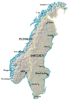
Norway: Geography
|
Overall Dimensions: From Northeast to Southwest, the length of Norway is approximately 1,100 miles. At the widest, the width is 267 miles. The coastline' length is almost impossible to measure as it is heavily indented with fjords and includes many islands. Norway covers an area slightly exceeding 125,000 square miles. Fjords: Fjords are ocean inlets that were caused by glacier movement. They often are deeper in their middle and upper reaches than at the ocean. The Oslo Fjord is on the southern coast of Norway. The Sogn Fjord on the west is Norways longest and deepest fjord and the Hardanger Fjord in the southwest is the second largest. Glaciers: There are probably over 1,500. glaciers in Norway today and they cover an area of over 1,000 square miles. These glaciers are NOT left over from the last ice-age but instead have mostly been formed in the last 2000 years with the size decreasing in the last century. Climate: Although it is essentially at the same latitude as Alaska, the Gulf Stream brings a warmer climate to Norway. This keeps the fjords from freezing, even in the Arctic Finnmark region. Even more important are the southerly air currents brought in above these warm waters, especially during the winter. Elevation: Only 20% of Norway lies below 500 feet and most of this is valleys or low hills. There are mountains, high plains, and plateaus accounting for the rest of the land. |